


Trip Rating
Difficulty 5 out of 5
5 of 5. Level 2 skills or higher, depending on conditions.

Description
This is my favourite day trip in Ontario. It comes with some logistical challenges: busy towns, crowded launch sites, and parking fees. But that's why you're here. I'll walk you through the whole route.
Cove Island is the largest in the Fathom Five archipelago. The south side is full of channels and inlets that feel completely isolated, almost eerie near Boat Passage. The islands here are larger, farther apart, and more exposed than those on the east side of Georgian Bay. The payoff is huge: unique scenery, rolling open-water waves, and dozens of visible shipwrecks. Many paddlers wrongly dismiss this area as unsuitable. Consider this a challenge to rethink that.
When I first studied the area on charts, "The Gut" stood out immediately. After gaining confidence on the Franklin, Mink and McCoy route, I decided it was time to explore it.

My first attempt was a disaster. Boat Passage is nearly impassable. Think knee-deep mud, jagged rocks, and unhappy paddlers. But exploration is part of the fun. Don't worry, the route below works every time.

① Little Tub Harbour → ② Coconut Joe's → ③ Chi-Cheemaun Dock
We handrail the south shore to Coconut Joe's, then continue to the Chi-Cheemaun dock. Be mindful not to impede the ferry. Once past the dock, you get your first sweeping view of the archipelago.

Fathom Five Archipelago on a foggy day
④ Doctor Island → ⑤ Russell Cove
Doctor Island is a perfect wind break. Russell Cove can be hard to spot from the water but is a great timing point if you want to watch the ferry.
Park regulations
Apart from Flowerpot Island, accessing, landing on, or tying off to any island inside Fathom Five National Marine Park is prohibited.
Kayaks are not permitted in the Lighthouse Point restricted area at any time.
Recreational drone take-off and landing is prohibited throughout the park.

⑥ Shipwreck Zone
The south shore of Cove Island is littered with shipwrecks. Some are exposed above the surface. Russell Reef can get extremely rough. This is why so many wrecks are here.

Approaching Turning Island
⑦ Russell → Turning Island (1 nautical mile crossing)
This is the longest open crossing and can be a rodeo with a southwest wind. Once across, you're fully outside the tourist zone. Few paddlers go this far.

Channels → Laronde Harbour
The southwest side of Cove Island is easy to get lost in. Use the northwest channel around Peters Island. The limestone formations here are carved by decades of wave action.

⑧ The Gut
The Gut is a natural seiche, a surge that reverses direction every 15 minutes or so. Even on calm days, the current is strong. During high water, it becomes a standout Great Lakes phenomenon. No one ever forgets seeing it.

⑨ Otter Islands
The Otters have incredible rock formations, a known otter colony, and a massive cavern we call "The Parking Garage." This is one of the most scenic areas on the route.

⑩ Hole in the Wall
The cliffs, coves, and formations here are unforgettable. You also get a sweeping view of Flowerpot, Echo, and Bears Rump Island before heading back.

⑪ The Otter Island Transit
Pull out chart 2235 or 2274 and you will see a line running through the channel here, labelled 040.5° one way and 220.5° the other. That is a transit, which North American charts usually call a range. It runs through two lights on the Otters.
Range lights are always built as a pair, one lower and nearer the water, one higher and set back behind it. The trick is that you do not need a compass to use them. Line the two up so one sits directly above the other and you are on the charted line. Let them drift apart and you are off it, and the direction they open tells you which way you have been pushed.
A vessel running inbound on 220.5° holds that alignment and lets the lights, not the helm, tell it whether wind and current are setting it off course. If the upper light slides right, the boat has been set left of the line. Steer toward the upper light and the pair closes up again. That is the whole technique, and it has been keeping ships off Russell Reef for longer than any of us have been paddling.
For us it is the cheapest navigation aid on the route. On a day with any set running through the channel, a transit shows you leeway faster and more honestly than a deck compass, because it is a position line with no instrument error in it. Even if you never intend to follow the line, stop here and watch the two lights close and open as you paddle across them. Everyone on the trip should be able to explain what they are seeing before we turn for home.
Why a transit beats a compass
A transit is among the oldest aids to navigation and still the most accurate one you can carry, because you are not measuring anything. There is no variation to apply, no deviation to correct, no instrument to read wrong. You are only looking. Two things are either lined up or they are not.
It also sharpens as you close on it. The nearer you get to the front light, the less sideways drift it takes to open the pair, so the transit becomes most sensitive at exactly the point where being off the line matters most.
Launch Spot Options
Parking is limited. Your best strategy is to drop your gear, then walk from a legal parking area.
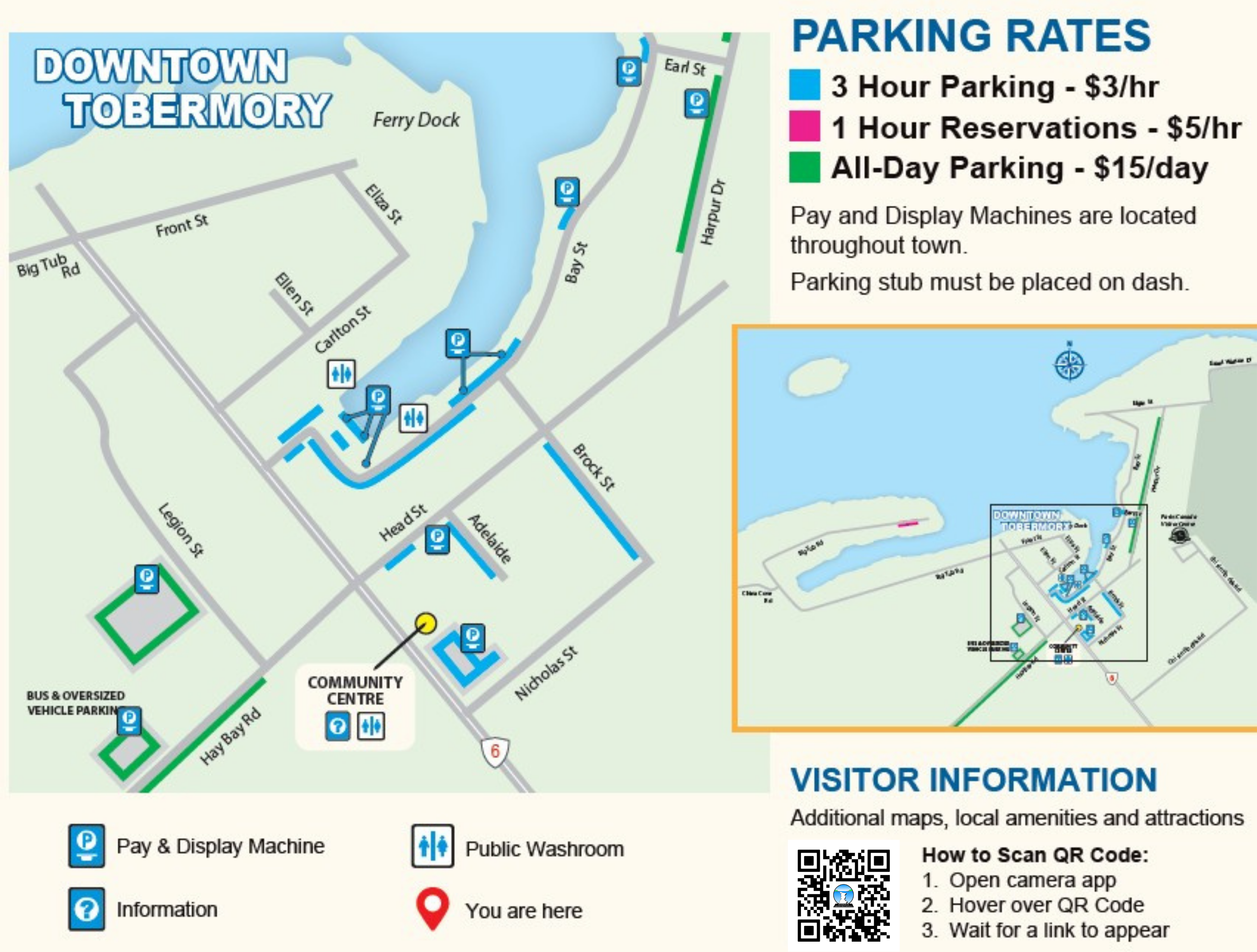
Tobermory paid parking, 2026 season
Paid parking is in effect in Tobermory from May 15 to September 15, covering both municipal lots and on-street parking. Signed restrictions are enforced year round.
3 hour parking: $3.00 per hour
1 hour reservations: $5.00 per hour
All day parking: $15.00 per day
Pay and display machines are located throughout town. The stub must be placed on your dash.
Big Tub Road: reservations required May 15 to September 15. Booked online in one hour blocks at $5.00.
Little Cove: reservations required. Four hour bookings at $20.00, available up to 14 days in advance. A valid Parks Canada pass must also be displayed.
A Parks Canada pass is not valid in municipal parking lots. They are separate systems and you may need both.
Rates change season to season. Check the Municipality of Northern Bruce Peninsula parking page before you travel.
Note to commercial companies running courses here
Use your trailer to unload your group's kayaks at the main dock in Tobermory. There is a special parking spot for you to use, it's clearly marked. You need to pay Karla or a dock hand $7.50 per kayak per day to launch. After unloading, vehicles must be moved to the auxiliary parking lots on Legion Street or Hay Bay Road before returning on foot to the dock area.
Option 1: The Boat Ramp
$7.50 per kayak, plus parking. A dockhand collects payment via debit.

Apres Options
1. Tacomory
Great tacos. The vegan bowl is my go-to.

2. Las Chulas
Authentic Mexican food and beer. The veggie burrito is incredible.

3. Shipwreck Lee's
Great patio, great fish and chips, and the ring game is addictive.

Paddle this route with us
This trip requires Level 2 skills or higher, depending on conditions. We run our Paddle Canada Level 2 course in these exact waters.
0 comments